The word derecho sounds like it should be on a taco menu, but it is actually one of the most serious flavors of severe weather in North America. If you have ever stepped outside after a night of storms and found whole neighborhoods of trees knocked down like spilled matchsticks, yet no single twisting “tornado track,” a derecho is one possibility meteorologists consider.
I taught high school physics for a decade, and the easiest way I found to explain derechos is this: a tornado is like a drill bit. A derecho is like someone swinging a giant, fast-moving broom across the landscape. Both can wreck a town. The patterns they leave behind are very different.
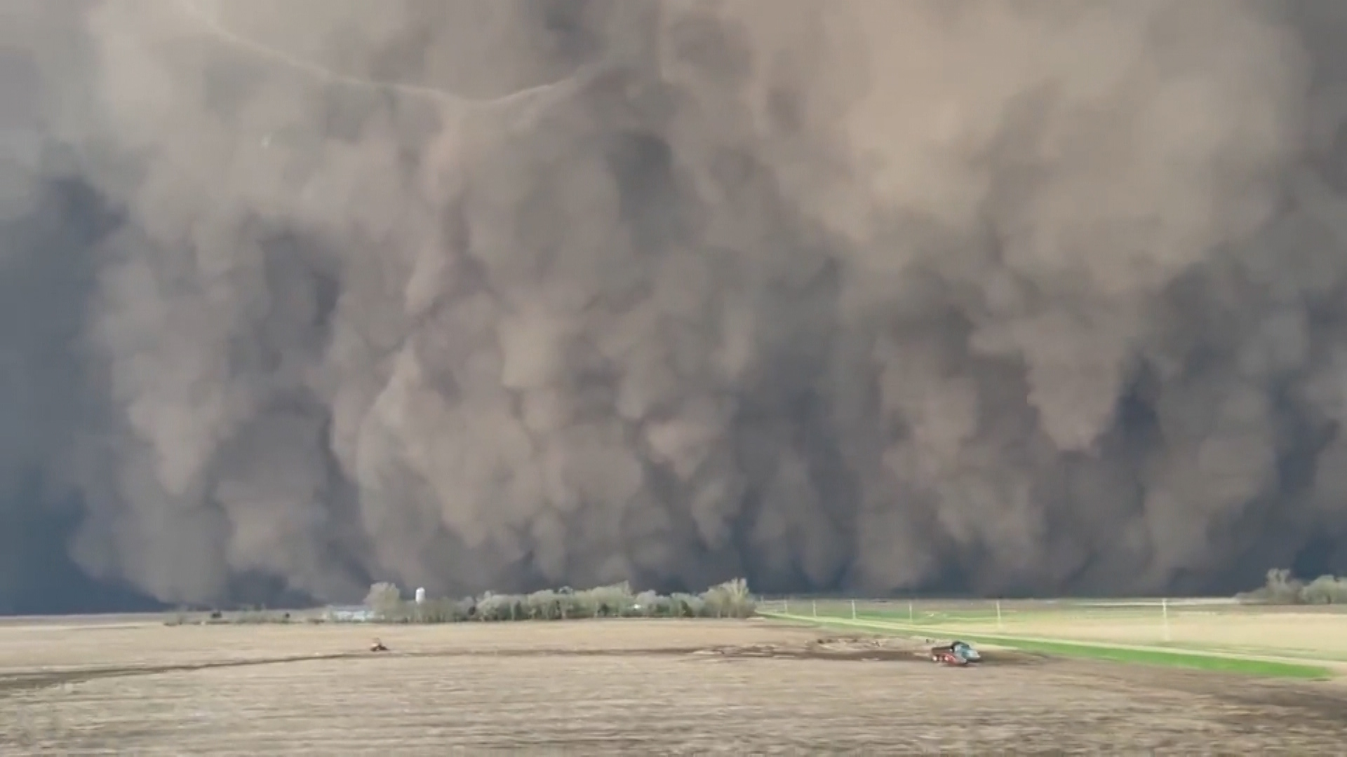
Derecho, in plain language
A derecho is a long-lived, widespread straight-line windstorm produced by a large, organized group of thunderstorms, usually a fast-moving squall line. “Straight-line” is important: the damaging winds typically blow in the same general direction, rather than rotating tightly around a central vortex the way tornado winds do.
Think of the thunderstorm line as a moving machine. As it surges forward, it can push out powerful bursts of wind near the ground called downbursts and outflow. When that machine stays organized for hours and keeps laying down damaging wind over a huge distance, you have the setup for a derecho.
What qualifies as a derecho?
Meteorologists do not use “derecho” as a vibe. It is a classification based on measured winds and a continuous, connected damage swath that stretches a long distance. Also worth saying out loud: plenty of severe thunderstorm wind events are not derechos, because they are too short-lived, too patchy, or too localized.
Core criteria (the big two)
A widely used definition in meteorological literature and training materials relies on two main checks:
- Damage swath length: The storm must produce a swath of damaging winds that is typically at least about 240 miles (roughly 400 km) long.
- Wind severity: Along that swath, there must be multiple reports of severe wind gusts, traditionally at least 58 mph (50 knots, 93 km/h), coming from observations such as weather stations, instrumented sites, or reliable damage indicators.
How the reports are distributed matters
It is not enough to have one isolated hurricane-force gust and then a lot of minor wind. A classic derecho shows numerous severe wind reports spread along the track, and many definitions also require a handful of “significantly severe” gusts (often around 75 mph or higher) embedded within the broader event.
Exact thresholds can vary a bit depending on the organization compiling the event and the quality of available observations. The point is consistency: a derecho is not one downburst, and it is not a short-lived burst of wind damage. It is a long corridor of damaging straight-line winds from an organized thunderstorm system.
Derecho vs. tornado: the damage patterns
If you only remember one distinction, make it this: tornadoes rotate; derechos surge forward.
What tornado damage tends to look like
- Narrower path, often with sharp edges
- Convergent debris: trees and debris can point inward toward the center of the track because air is spiraling into the vortex
- Highly variable intensity over short distances
- Shorter-lived compared with the multi-hour lifespan of many derechos (though long-track tornadoes do happen)
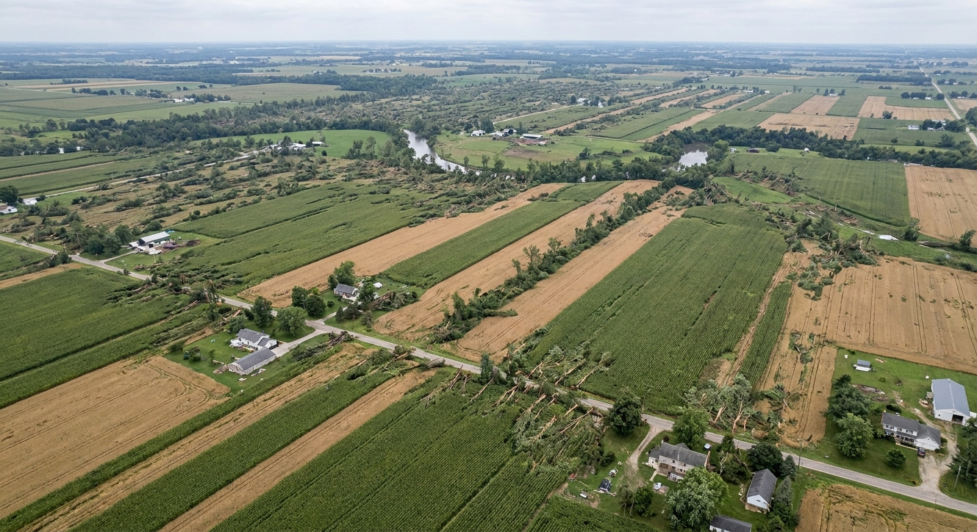
What derecho damage tends to look like
- Wider, more continuous corridor of impacts, sometimes with embedded hotspots
- Mostly consistent direction: trees and debris often lie generally the same way, reflecting the dominant wind direction
- Many communities affected in sequence as the thunderstorm line races forward
- Hours of production: the parent storm system can keep generating severe winds over a huge distance
Important nuance: a thunderstorm system can produce both tornadoes and a derecho-style wind swath. In other words, “it was a derecho” does not automatically mean “there were no tornadoes.” It means the defining feature of the event was the large-scale, long-track straight-line wind damage.
What is a bow echo?
When meteorologists talk about derechos, you will often hear the phrase bow echo. This is a common radar signature where a line of thunderstorms bulges outward like a bow pushed by a strong wind. At a high level, the concept is simple:
- Thunderstorms form a line.
- Strong winds inside and behind that line surge forward.
- The middle of the line accelerates, creating a bowed shape.
- The strongest straight-line winds are often near or just behind the leading edge of the bow, commonly tied to features like a rear-inflow jet.
You do not need to read radar like a pro to appreciate what it implies. A bow echo is a visual hint that the storm line has organized a powerful forward push, which is exactly the kind of structure that can maintain widespread damaging winds for a long time.
Why the label comes later
During the event, meteorologists may suspect a derecho based on storm structure, speed, and incoming reports. But the classification typically comes after there is enough evidence that the event met the criteria.
What a survey checks
To apply the derecho label confidently, investigators generally need:
- A mapped, connected damage swath showing that wind damage was continuous or near-continuous across a long corridor.
- Time continuity, establishing that the damage was produced by the same evolving thunderstorm system as it moved.
- Severe wind confirmation through direct measurements (weather stations, mesonets, anemometers) and/or damage-based wind estimates using well-understood indicators (for example, patterns of tree failure, structural damage consistent with certain wind speeds).
- Context to rule out look-alikes, especially isolated microbursts, separate thunderstorm clusters that happened to occur along a similar line, or tornado damage that could be mistaken for straight-line winds.
This is why you might hear early coverage describe “widespread wind damage” and only later see a post-event report confirming it as a derecho.
How derechos form
Derechos are most common when the atmosphere is primed for organized severe thunderstorms, especially in late spring and summer in parts of the Plains and Midwest. That said, cooler-season derechos can and do happen, including in the Southeast.
They feed on the same ingredients that power severe thunderstorms:
- Warm, moist air near the ground that can rise easily
- Instability, meaning rising air keeps rising
- Wind shear, a change in wind speed or direction with height that helps storms organize rather than collapse quickly
- A trigger such as a front or other boundary that initiates and focuses thunderstorm development
Once a line of storms develops, rain-cooled air can surge outward along the ground, creating a fast-moving pool of dense air. If the system stays balanced, continually regenerating storms on its leading edge while strong outflow keeps pushing forward, the line can become a long-distance wind producer. That is the heart of a derecho: persistence plus scale.
Safety: what to do
Because derechos are made of thunderstorms, the warnings you see may sound familiar: severe thunderstorm warnings, sometimes tornado warnings, and sometimes special language about destructive winds. The hazard is not subtle. These winds can reach speeds comparable to weak or moderate tornadoes, but over a much larger area.
- Treat destructive wind warnings like tornado warnings. Go to a sturdy building, lowest level you can, away from windows.
- Have more than one way to get warnings. Wireless Emergency Alerts, a NOAA Weather Radio, and local alerts or apps are a good trio if you can manage it.
- Mobile homes and vehicles are dangerous places in extreme winds. Plan ahead for where you will shelter.
- Watch for falling trees and power lines before and after the storm. Many serious injuries happen during cleanup.
- Do not assume it will “just be rain.” A derecho can arrive with little fanfare and then hit like a freight train.
Quick FAQ
Is a derecho a tornado?
No. A derecho is a widespread straight-line wind event from a long-lived thunderstorm system. Tornadoes are rotating columns of air. The same storm complex can produce both.
How long does a derecho last?
Often several hours. The defining feature is that it remains organized long enough to produce a long, connected corridor of damaging winds.
Why is it called “derecho”?
The term comes from Spanish for “straight” or “direct,” referencing the straight-line nature of the wind damage compared with the twisting damage signature of tornadoes.
Can radar confirm a derecho by itself?
Radar can strongly suggest a setup, especially with a bowing line of storms, but the derecho label relies on the observed and surveyed wind and damage footprint.