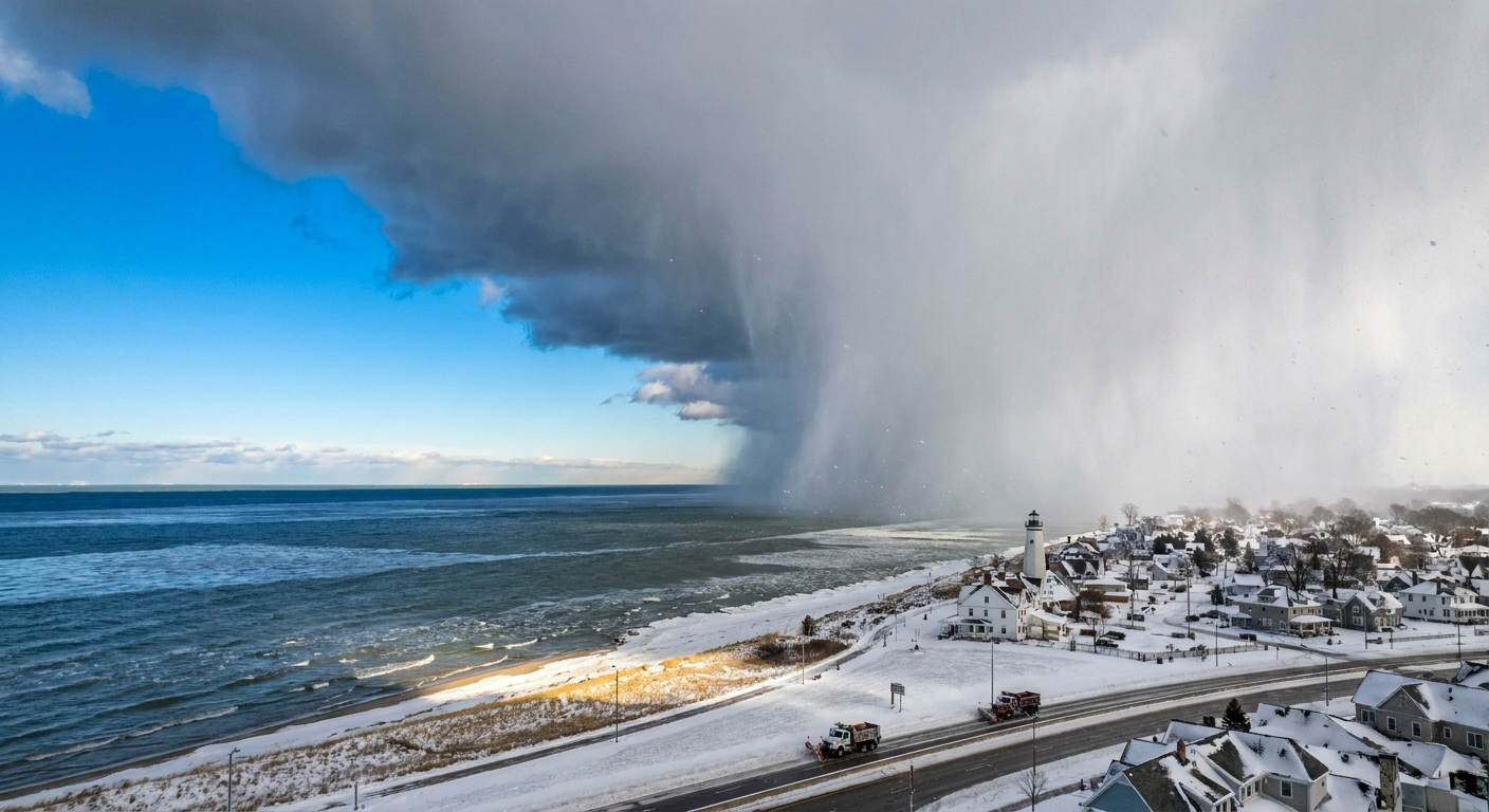
The first time I really felt lake-effect snow, I was driving along the southern shore of Lake Erie. The sky ahead looked like someone had drawn a pencil line across it, a hard edge between clear blue and a gray-white curtain. I crossed that line and suddenly it was full winter: thick flakes, low visibility, and that muffled hush that only fresh snow can create. Five miles later, the sun was back out like nothing happened.
That whiplash is the calling card of lake-effect snow. It is not magic, but the physics is wonderfully dramatic. Cold air slides over comparatively warm lake water, the air becomes unstable and moisture-loaded, and then it unloads that moisture as snow in narrow bands that can park over one community and barely dust the next.
The core idea: cold air over warm water
Lake-effect snow starts with a temperature mismatch. A cold air mass moves across a lake that is warmer than the air above it. The lake acts like a giant heat and moisture source.
Two key things happen at the same time:
- Heat flows upward from the lake into the lowest layer of air, warming it from below.
- Water evaporates into that air, raising its humidity.
Warm, moist air near the surface is lighter than the colder air above it, so it rises. As it rises, it cools. As air cools, its capacity to hold water vapor drops, so some of that vapor condenses into cloud droplets and ice crystals, building clouds that can turn into vigorous snow showers.
In classroom terms, this is convection, the same basic engine that drives summertime thunderstorms. The difference is the fuel is lake warmth, and the precipitation falls as snow because the air is cold enough aloft.
Why the snow falls in narrow bands
If the Great Lakes were a pot of simmering water and the atmosphere were a lid, lake-effect snow would be the steam finding the cracks. The bands form because the wind and the lake’s shape organize rising air into corridors.
Fetch: the lake’s runway length
Fetch is the distance the wind travels over open water. A longer fetch gives the air more time to pick up heat and moisture. It also gives convection more time to organize.
That is why wind direction matters so much. A small shift in wind can change the fetch from crossing the short way to crossing the long way, and the snow response can jump from modest squalls to a full-on firehose of flakes.
Instability: taller clouds from a warm base
Forecasters talk about instability when air wants to rise because it is warmer near the surface than above. Warmer lake water makes the surface layer buoyant, which encourages stronger upward motion and deeper cloud growth.
A common benchmark is the temperature difference between the lake surface and the air around 850 millibars, roughly 5,000 feet up. When the lake is about 13°C (23°F) warmer than that layer or more, the setup is often favorable for robust lake-effect, assuming the other ingredients cooperate.
Wind shear: keeping the band together
For a clean, intense band, the wind should not change too much with height. If winds veer or increase rapidly as you go up, the rising plumes tilt and get torn apart. That can spread snow out into broader, less focused areas.
Why totals can jump over a few miles
Lake-effect snow is famous for producing absurd gradients, like 2 inches in one place and 20 inches a short drive away. That happens because the heaviest snow is often confined to a band that can be only a few miles wide.
Here are the biggest reasons your driveway and your friend’s driveway can live in different realities:
- Band position: The band is like a spotlight. Under it, snowfall rates can be intense. Outside it, you may just see flurries or nothing at all.
- Small wind shifts: A 10 to 20 degree change in wind direction can push the band’s aim point to a new town.
- Band motion and parking: Sometimes the band drifts steadily. Other times it stalls for hours over the same corridor, piling snow in place.
- Local geography: Hills and ridges downwind can squeeze extra lift from the air. More lift means stronger cloud formation and heavier snow.
- Near-shore warmth: Early in the season, the lakeshore can be a touch milder. That can mean wetter snow, more compaction, or even some melting on roads, while colder inland areas rack up fluffier, higher-ratio snow that piles up faster.
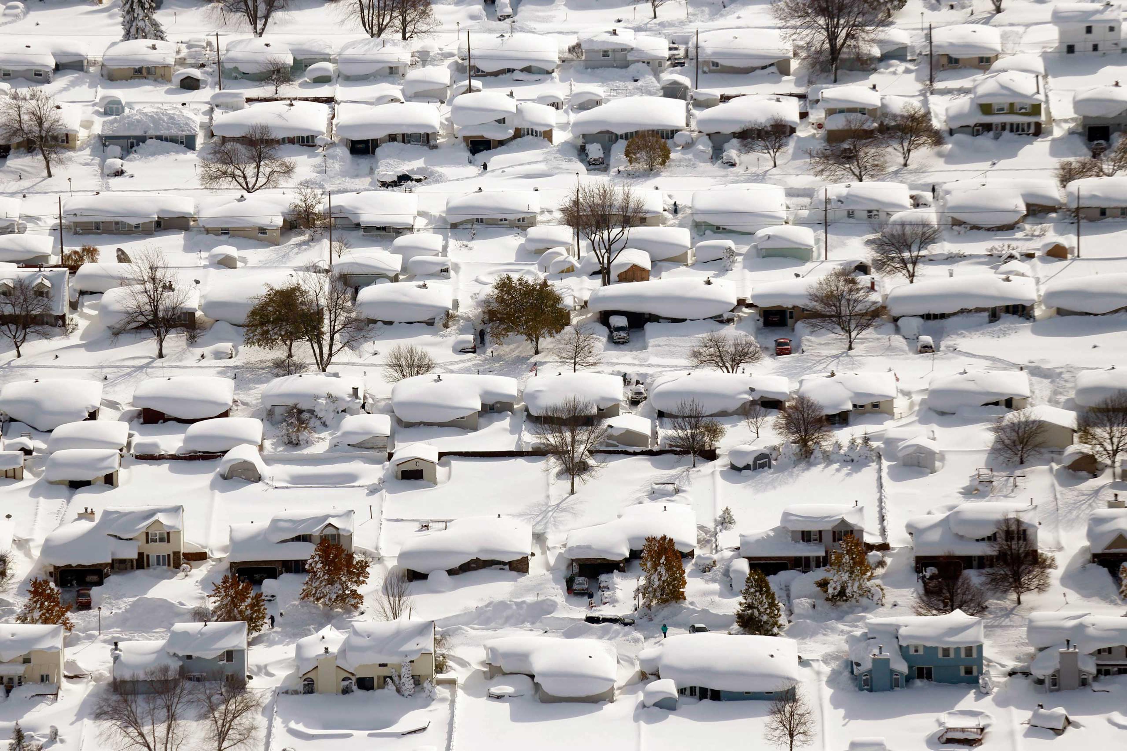
The Great Lakes setup
The Great Lakes are large enough to behave like inland seas. In late fall and early winter, they often remain relatively warm while the first major Arctic outbreaks begin spilling south.
That timing is critical. Open water is a moisture source. When ice cover becomes widespread, evaporation drops sharply and classic lake-effect from that lake becomes much harder to sustain, although narrow events can still spin up over remaining open water and lake-enhanced snow can still occur with larger storms.
Each lake has its own lake-effect personality:
- Lake Superior: Huge fetch potential and very cold air masses nearby can create strong events, especially for Michigan’s Upper Peninsula and parts of northern Wisconsin and Minnesota.
- Lake Michigan: Long north to south orientation means certain wind directions can create lengthy fetches and significant snow in western Michigan and northern Indiana.
- Lake Erie: Shallow, so it can freeze extensively in colder winters and shut events down. But when it stays open, it is a prolific snow producer for areas east and southeast of the lake, including the Buffalo region.
- Lake Ontario: Deep and less likely to fully freeze, which can extend lake-effect season. Its downwind regions can see persistent bands.
One cold outbreak can produce very different outcomes around the lakes because the wind direction relative to each lake changes the fetch and the favored snow corridors.
From lake to land
It is tempting to imagine the lake simply making snow and then tossing it onto the nearest shoreline. In reality, the atmosphere is doing the work, and the shoreline is where the system often sharpens.
Friction and convergence near shore
Air moving over water experiences less friction than air moving over land. As the flow hits land, it slows a bit near the surface. That can cause air to pile up and converge, forcing air upward right near or just inland from the shore. More lift means more cloud growth and more snow.
Terrain boosts
Downwind hills can act like a ramp. When moist air is pushed up a slope, it cools and condenses faster, enhancing snowfall. If you have heard of places like the Tug Hill Plateau east of Lake Ontario or the higher terrain south of Buffalo near the Chautauqua Ridge, you have heard of this effect in action.
Lake-effect vs winter storms
Big, sprawling winter storms are typically driven by large-scale weather systems, like low-pressure areas that pull in moisture from oceans and the Gulf of Mexico, and spread snow over broad regions.
Lake-effect snow is more localized. It is powered by:
- Cold air advection moving over open water
- Heat and moisture flux from the lake to the atmosphere
- Convection and organization into bands by wind and geography
You can get both at once. A larger storm can provide the cold air and background lift, and the lake can then supercharge snowfall in the favored band zones. When a synoptic storm is the main driver and the lake mainly adds an extra punch downwind, forecasters often call it lake-enhanced snow rather than pure lake-effect.
How to spot it
If you live in lake-effect country, you start to develop a sixth sense for it. Here is the quick, everyday checklist:
- Cold air is arriving from Canada or the interior, not from the south.
- The lake is still open and not locked under widespread ice.
- Winds are steady in one direction for hours, so bands can organize and persist.
- The forecast mentions bands or localized heavy snow, especially downwind of a lake.
And the big practical takeaway: the most important question is often not Will it snow, but Where will the band set up.
Safety and real-world impact
Lake-effect is not just a snow amount story. It is a visibility story. Under a strong band, conditions can flip from dry pavement to whiteout in minutes, especially on highways that run parallel to the shoreline.
If you are traveling, do not anchor on a regional snowfall total. Check the most local forecast you can find, watch radar, and pay attention to short-fuse alerts. In lake-effect country, being 10 miles off the band can be the difference between an easy drive and a long, tense one.
FAQ
Why does lake-effect snow sometimes look like a wall?
Because it can be. The edge of a band can be very sharp, especially when winds are steady and the band is well organized. On one side, sinking or drier air limits cloud growth. On the other, rising moist air is producing thick clouds and heavy snow.
Can lake-effect snow happen at night?
Yes. Unlike daytime heating driven convection in summer, lake-effect is fueled by the lake’s warmth and moisture relative to the air. It can run day or night as long as the temperature contrast and wind setup remain favorable.
Does lake-effect always mean huge snowfall?
No. Sometimes the air is cold but too dry, the lake is partly iced over, the fetch is short, or wind shear is strong enough to disrupt band formation. The result can be scattered snow showers rather than a persistent band.
Why does one town get buried while the next town barely gets a dusting?
Because the band can be narrow and sensitive to wind direction. A small change can shift the band’s aim point, and snowfall rates inside the band can be dramatically higher than outside it.
Is it always one single band?
No. Sometimes you get one dominant streamer that looks like a laser on radar. Other times, especially with different wind profiles, the snow breaks into multiple shorter bands or messy clusters of snow showers.
The lake-effect aha
If you remember only one mental picture, make it this: cold air is like a dry sponge sliding over a warm, wet countertop. The lake loads that sponge with water vapor and heat. Then, downwind, the atmosphere wrings it out as snow, often in a tight stripe.
So the next time you see radar showing a single streamer of snow aiming like a laser across a lake, you are watching physics in motion: evaporation, convection, and wind all teaming up to make winter wildly uneven, one neighborhood at a time.